To the precision

To the precision of the general ecological model of a river network
IVAN TUŠA
Regional Museum in Šumperk, Hlavní 22, 787 31 Šumperk, the Czech Republic
Abstract: Two of the most well known and often cited ecological models of streams and rivers (1 – Illies, Botosaneanu, 2 – Vannote et al.. 1980) are evaluated critically and their greatest imperfections are analyzed. A new model is constructed using pieces of the above given models. The new model that is constructed does not operate only with one stream bed but with the entire river network.. Three pictures are included..
Keywords: Ecological model, river network, Central Europe, terminology of river-zones.
INTRODUCTION
Many ecological river models have been proposed. Their survey with short descriptions is given e.g. by Hawkes (1975). His information must be, of course, supplied with
new references, especially with paper by Vannote et al (1980), see also Allan (1995). Two of the most known ecological river models are those by Illies and Botosaneanu (1963) and Vannote et al. (1980).
1) Illies´model is shortly characterized e.g. by Hawkes (1975), p. 366:
„ (i) Rhithron is defined as that part of the stream from its source down to the lowermost point where annual range of monthly mean temperatures does not exeed 20 °C. The current velocity is high and the flow volume is small. The substratum may be composed of fixed rock, stones or gravel and fine sand. Only in pools and sheltered area si mud deposited.
(ii) Potamon is the remaining downstream stretch of river where the annual range of monthly mean temperature exceeds 20°C, or in tropical latitudes, with a summer maximum of the month mean exceeding 25°C (Illies, Botosaneanu 1963). The current velocity over the river bed is low and tends to be laminar. The river bed is mainly of snad or mud, although gravel may also be present. In the deeper poos oxygen may be depleted, light penetration limited and mud deposit
The two reaches were further characterized faunistically. The organisms of the rhithron were mostly cold stenotherms and associated with running, well aerated waters. In contrast those of the potamonn were eurytherms or warm-water stenotherms, composed mostly of organisms of lentic waters, often with a rich development of plankton in conrtast with the spars rhithron plankton. Although species differences occured in different biogeographical regions, it was found that the same families tended to be represented in the rhithron and potamon respectivelly of river in different continents.“
Illies´ river zone classification (Illies 1961) for world-wide application is shown on Fig 3. Schematic meridional section from temperature north to temperature south illustrating the effects of geographical conditions related to altitude and latitude, on the zonation of rivers into rhithron and potamon.
Natural communities in running waters are very objectively rendered also on graphic plates by Sládečková, Sládeček (1998). They used, of course, for their river classification also the Illies´model rhithron/potamon (see above).
2) Description as well as the picture of the model of RCC (Vannote´s model) river continuum concept may be found e.g. in the book by Allan (1995), p. 276 – 277: „The river continuum concept (RCC) is a bold attemp to construct a single synthetic framework to describe the function of ecosystems from source to mouth and accomodate the variations among sites that results from differences in their terrestrical setting (Vannote et al. 1980).“
Descrition of this model is completed by a picture with the title: „Generalized depiction of the relationship between stream size (order), energy inputs and ecosystem functions expected the river continuum concept.“ (See also Fig 2).
MATERIAL AND METHODS
The proposed model of river network is based on the author´s research of conditions as well as communities in some rivers in the Czech Republic and Slovakia (upper Morava, and its tributaries), upper Vltava in the Šumava Mts, Lubochňanka and Revúca in the Velká Fatra, Mts, Slovakia (Tuša 1987, 1992, 1993, 1993 and 1994, 2005 etc.). Determinants of conditions as well as communities found in the terrain has been simultaneously compared with items in the models published: rhithron/potamon (Illies and Botosaneanu 1963), orders of streams (Vannote et al. 1980, Allen 1995).
The present author has not agreed with simplified reality and also does not agree with the way the well known gives models are used in many papers, e.g. Helan et al. 1973, Krno 1982, Moon, Wimmer 1994, Helešic 1995 etc.).
A key point of the new model (Fig.1) is its graphical (left) part. This idea has been developing since the 1990s as an effort to create a graphic picture of a hypothetical and general river network.
To describe the new model of a river network as it will be discussed, it is necessary to establish some new terms:
– the main stream of a region: usually the longest river rising at the highest altitude range of a region and flowing down upto lowlands or empties into the sea
– the side streams of a region: tributaries of the main stream of a region
– complete streams: streams having formed all known and possible river zones
– incomplete streams: streams within them only some known and possible river zones
may be distinguished
This graph is not only a group of casual parallel lines without a mutual relations but this graph also illustrates the main stream of any greater region (thick line in the middle) and its left as well as right direct tributaries (thin lines to the left and to the right of the thick line).
The terminology of altitude ranges is taken from the paper by Landa, Soldán (1989).
Pictures of up-streams and down-streams communities are in circles (Fig 2), taken from Vannote et al. (1980) as well as plates by Sládečková, Sládeček (1998) (see reference in Fig 1 and notes to them) were found to be suitable to use also here, in the new model (Fig 1) for short characteristics of communities assumed.
Distribution of determinants of conditions as well as communities are based on relatively well known fact, that in a determine region “ nearly all is nearly everywhere“ (stony, sand, muddy bed…etc., occurence of some species: in the mountain streams as well as in lowland rivers), but only somewhere the majority of some factors or taxa is typical or predominant. In the Fig 1 typical and and the most frequent condiotions values as well as taxa (communities) are given without parentheses and untypical values and taxa (communities) in parentheses. Most of the values of particular factors of environs or taxonomic structure of cummunities are given as ranges: „from-to“.
RESULTS
a) DESCRIPTION OF RIVER NET ACCORDING TO THE NEW MODEL
The construction of the suggested general model of a hypothetical river network is based on the fact, that within a given altitude stretch of the main stream of a region, only streams (its tributaries) rising in the same or higher altitude ranges can empty into it.
For example, into „the higher mountain range“ (at altitude 800 – 1000 m) of the main stream of a region, streams only from the range 800 – 1000 m and the streams from the range above 1000 m can empty in the main stream. Similarly, downstream into the main river of the lower mountain range (600 – 800m) streams from the ranges 600 – 800 m, 800 – 1000 m as well as from the range above 1000 m can empty into the main stream.
Short outline of the river network according to Fig1 may be given as follows (see also Fig 1,2 and study by Sládečková, Sládeček 1998):
In the highest (alpine, mountain) zones of a given region only springs and small brooks and rivers are present. Here the main stream of the region mostly does not differ much form side streams within the region. All of them are stony, pure, with low value BOD5, cold, many with stretches of streams characterized by torrent riffles with very high current speed, etc…Flora/fauna as on Fig 2, Communities I,II, partly also III.
Down river, in higher and lower colline zones there is a greater variety of streams and rivers to be found: spring, spring brooks, small river as well as larger river, i.e. streams of Irst, IInd, IIIrd …order. Also conditions as well as communities among the main streams and side (especially smaller) streams of the region may be very different etc…Flora/fauna as on Fig 2, Communities II (I,III) – main stream, I,II (III) – side streams.
In the Czech Republic as well as probably in the whole Central Europe the administrative cross the boundary between salmonid and non-salmonid streams may be usually found at the altitude 300 – 400 m (Štefáček 1995).
Also in the lowest (planar) zone we may sometimes find next to the large deep rivers with warm, slow and turbid water and muddy bottom smaller, torrent streams and rivers with colder and relatively pure water etc…Flora/fauna.: as on Fig 2: in the main stream an in the larger side streams Communities II,III (I). in the smaller side streams Communities I,II,III.
Examples of concrete species for different types of streams in the longitudinal zonation are
given e.g. on plates in the paper by Sládečková, Sládeček (1998), see also notes at Fig. 1.
But it must be taken into consideration, that for any given model of a stream we are able only to list possible taxa (species) for definite factor spectrum of environs. Only some from these taxa will occur at particular localities (e.g. Hynes 1070, Macan 1974, Allan 1995).
Morphology of streams and rivers all over the world (slope, bed, composition of the bottom, current, bank vegetation etc. and their longitudinal zonation) shows, in general, similar or the same features. It is necessary, of course, regional untypical speciality presumed. Also similar or the same morphological (ecological) types of benthic as well as pelagic communities may be expected here (compare e.g. common differences between communities of stony, gravel, sand, muddy bottom etc., see e.g. Hynes 1970 a.o.).
Temperature of stream water as well as temperature conditions of the whole regions (summer maximum, yearly mean, etc.) are one of the most important condition determinants which are modified according to the geographical position, especially the latitude.
It seems, therefore, that the model of a hypothetical catchment suggested here shows validity for the whole world. Only temperature conditions and items dependent on it (oxygen a.o.) must be adapted according to the latitude.(compare also Illies 1961 and Fig.3)..
In tropics as well as subtropics stony bottom and riffles are combined also with relatively high water temperature (yearly max. 20 – 30 °Celsius). In the moderate zones and also in the regions near to the Earth´s poles stony bottom and riffles are combined largely with lower temperature (yearly max. below 20 °Celsius).
Without streams and river having typical water temperature (for given latitudes and altitudes) we sometimes find streams under a typical temperature conditions.
The author of this paper know two cases of thermally atypical streams in the Czech Republic: 1) karstic streams – their water temperature usually is lower than it corresponds with their altitude (see e.g. paper by Sukop 1976). 2) Teplá Vltava River near Lenora, Borová Lada, etc.. This river (with relativelly small slope) is known to have maximum summer water temperature around 20°C at 800 – 900 m above sea level (Tuša 1993, Landa et al. 1995). Any other mountain streams with such high water temperature has not been known from the Czech Republic and Slovakia.
b) PROPOSALS TERMS FOR DIFFERENT STREAM TYPES FOR RIVER CLASSIFICATION
The suggested general model of a river network requires one to propose many relatively descriptive terms (and their combination) for precisely indicating as well as delineating different types of streams and rivers, and their zones using some words, e.g.:
Central European – higher mountain – mostly stony stream IInd order – unpolluted – thermally typical etc.
It seems that some international rules for river classification and terminology for different types of streams and rivers should be formed.
DISCUSSION
Published ecological models of stream network (the most known and used see Illies and Botosaneanu 1963 and Vannote et al. 1980), are very common, suitable only for general description of relations and communities in streams (e.g. in textbooks and general works on streams and rivers as Hynes 1970, Pennak 1971, Hawkes 1975, Holčík 1989, Lellák, Kubíček 1991, Allen 1995). Using of these models for classsification result in many confusions. Some of them are given below:
1)Only on the main stream of a region (as well as on some large-long its left and right tributaries) all of the known river zones are (may be) formed. The longitudinal zonation only of these large streams correspond to the description and illustrations given by Illies, Botosaneanu (1963), Vannote et al.(1980), see also Lellák, Kubíček (1991), Allen (1995) etc.
2) Comparing description of the Illies model rhithron /potamon (see Introduction) and Fig 3 we may see one inaccuracy or creation of confusion. For example, equator mountain streams and lowland streams at the North or the South pole both named as „rhithron“ are similar only in temperature conditions.
3) Spring as well as spring brooks of a definite region, streams of Ist or IInd order show similar conditions and communities also at different altitudes. But it is confusing to organize similar streams from different altitudes into the same categories. Many authors, of course, have done it.
4)The greatest error is, doubtless, when we sum e.g. several samples from streams Ist or IIdn order from different altitudes into one sample e.g. „epirhithron“ etc (see e.g. Helešic 1995).
5) The great difficiency of the models by Illies as well as Vannote as well as the others is a fact that structure of the river network ecosystem is demonstrated on only one river bed.
The one bed river model very limits creative thought on river ecosystems as well as new ideas and approaches to new research.
CONCLUSION
We may conclude that new models of streams for classification of particular rivers and river networks are necessary to form and discuss.
It seems, that the study and comparison of differences and similarities of conditions as well as communities in streams of the Irst, IInd, IIIrd etc…orders (=…rhithrons“) at various altitudes in different river network may be the first step of resarch using this new model.
REFERENCES
ALLAN J.D., 1995: Stream ecology. Structure and function of running waters. 388pp. Chapman, Hall, London.
BALATKA B., SLÁDEK J., 1962: Říční terasy v českých zemích. 578pp. Geofond ČSAV, Praha.
HAWKES H.,A., 1975: River zonation and classification. In: Whitton B.A. (ed.): River ecology. Blackwell Sci.Publ. 725 pp. (pp. 312-374).
HELAN J., KUBÍČEK F., LOSOS B., SEDLÁK E., ZELINKA M., 1973: Production conditions in the trout brooks of the Beskydy Mountains. Folia Fac.Sci natur. Univ. Purkynianae Brunensis, Biol. 14:1-105.
HELEŠIC J., 1995: The stoneflies (Plecoptera as a model group of stream biomonitoring. Disertation thesis abstract. Faculty of Science, Masaryk University, Department of Zoology and Ecology, Brno. 35pp.
HOLČÍK J. (ed.), 1989: The freshwater fishes of Europe. Vol. 1, Part II, General Introduction to fishes, Acipenseriformes. 469 pp. Aula Verlag. Wiesbaden.
HYNES H.B.N., 1970: The ecology of running waters. 555pp. Liverpool Univ. Press.
ILLIES J., 1961: Versuch einer algemain biozonotischen Gleiderung Fliessgewasser. Int.rev.ges Hydrobiol., 46: 205-213.
ILLIES J., BOTOSANEANU L., 1963: Problémes et méthodes de la classification et de la zonation éologique des eaux courantes, considerées surtout du point de vue faunistique. Mitt.int. Verein.theor. angew. Limnol. 12: 1-57.
KRNO I.,1982: Structure and dynamics of macrozoobenthos of the River Lupčianka and its tributaries (The Low Tatras). (In Slovak with English summary). Biol. práce 27: 1-126.
LANDA V., HELEŠIC J.,SOLDÁN T., ZAHRÁDKOVÁ S., 1995: Stoneflies (Plecoptera)of the river Vltava, Czech Republic: a century of extinction. VIIIth International Conference on Ephemeroptera 14-18 August, 1995 and XIIth International Symposium on Plecoptera 18-20. August, 1995. Lausanne, Friebourg, Switzerland. 11pp + 3 tab.
LANDA, V., SOLDÁN T., 1989: The distribution of the order Ephemeroptera in Czechoslovakia with respect to water quality. (In Czech, English summary). Studie ČSAV,Academia Praha, 17, 1-170.
LELLÁK J., KUBÍČEK F., 1991: Hydrobiologie.257pp. Univerzita Karlova, Praha.
MACAN T.T.(l974): Freswater ecology. Longman 343pp.
MOOG O and WIMMER R. 1994: Comments to the water temperature based assessment of biocoenotic regions according to Illies, Botosaneanu. Ver. Internat. Verein. Limnol. 25: 1667-1673.
PENNAK R.W. 1971: Towards a classification of lotic habitats. Hydrobiol. 38: 321-334.
SLÁDEČKOVÁ A., SLÁDEČEK V.,1998: Natural communities in running waters of the Czech Republic. Acta Univ. Carolina, Environ.12:61-98.
SUKOP I. 1976: Annual cycle of the zoobenthos-the natural food of fish in troutbeck of the Moravian Karst. (In Czech, English summary). Acta Univ. Agricult. Brno, A, 24: 511-517.
ŠTEFÁČEK S. 1995: Rybářský průvodce po tekoucích vodách.206pp. Brázda, Praha.
TUŠA I., 1987: Structure, dynamic and production of zoobenthos in trout stream (Czechoslovakia). (In Czech, English summary). – Čas. Slez. Muz Opava (A), 36:193-218
TUŠA I., 1992: To the knowledge of the genus Lipooneura Loew, 1844 (Diptera, Blephariceridae) of Czechoslovakia. (In Czech, English summary). Severní Morava (Šumperk),63:29-42.
TUŠA I., 1993: : Research in the ecology of running waters with special reference to
the zoobenthos. 21pp. Okresní vlastivědné muzeum v Šumperku.
TUŠA I., 1993a: Larvae of the genus Atherix Meigen, 1803 (Diptera, Athericidae) in streams of Czechoslovakia. (In Czech, English summary). – Čas. Slez.Muz. Opava (A), 42:21-29.
TUŠA I.,1994: To the ecology of the Atherix larvae in streams of the Czech Republic and Slovakia. (In Czech, English summary). – Čas. Slez. Muz. Opava (A), 43:21-34.
TUŠA I. 2005: To the ecology of the mountain river with regard to the summer flood in 1997 and a new pumped storage plant (Divoká and Hučivá Desná River, Hrubý Jeseník Mts.). (In Czech, English summary). – Čas. Slez. muz. Opava, (A), 54:25-55.
TUŠA I. 2005a: To the precision of the general ecological model of a river network. 30 pp. Manuscript.
TUŠA I. 2006: To the precision of the general ecological model of a river network. (In Czech). – Sborník příspěvků 14. konference ČLS a SLS, Nečtiny 26-30. června 2006. 163pp (pp. 147-148).
VANNOTE R.L., MINSHALL G.,W. CUMMINS K.W., SEDELL J., R., CUSHING C.,E. 1980: The river continuum concept. Can.J.Fish.Aquat. Sci:37:130-137.
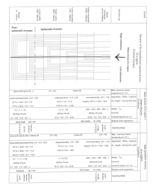
Fig1 General ecological model of a Central Europe river catchment area. Tuša, orig.
Notes to Fig 1.
I.
Bottom: St- stones, G- gravel, Sa – sand, M – mud. Vegetation: B – bryophytes, HP- higher plants, I.,II.,III.: communities in longitudinal profile of streams by Vannote et al.(1980) – see also Fig 2 and Allan (1995), 1,2,3,4,5: communities in different stream zones in the Czech Republic by Sládečková, Sládeček (1998), re-numbered: 1- (in cited paper Plate 1 and 2) = Crenon + Hypocrenon, 2- ( in c.p.Plate 3 and 4) = Epirhithron and metarhithron, 3 – ( in c.p. Plate 5 and 6) = Hyporhithron, 4 – (in c.p. Plate 7 and 8) = Epipotamon, 5 – (in c.p. Plate 9 and10) = Metapotamon., —– = administrative frontier between salmonid and non-salmonid streams in Czech Republic (according to Štefáček 1995).
II.
1) The others data given in Tab. 1 are undertaken from the following papers: Balatka, Sládek (1962), and Tuša (1994). The most of them are verified by the author´s own experiences
2) At communities I,II,III the size (order) of streams given by Vannote at al. (1980) are not taken into account here, aspecially in side streams at lower altitudes. In these smaller streams we may mostly found only small species of fishes as well as younger specimens of the bigger fish species.
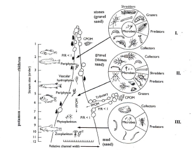
Fig 2 River ecosystem. Vannote ´ s and Illies ´model are combined here. Vannote´s model is taken from Allan (1995), see also Illies, Botosaneanu (1963), Hynes (1970), Hawkes (1975) a.o.
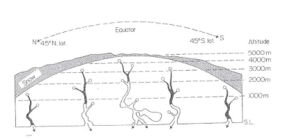
Fig 3 Generalized zonation of river into rhithron (black) and potamon (white) for worldwide application. After Illies 1961, taken from Hawkes (1975) p. 370.
Informace
Kontakt
Vlastivědné muzeum v Šumperku, příspěvková organizace
Hlavní třída 22, 787 31 Šumperk
Telefon: +420 583 363 070
E-mail: vmsumperk@muzeum-sumperk.cz
ID dat. schránky: 74xmakr
IČO: 00098311
DIČ: CZ00098311
Bankovní spojení: 333841/0100 (KB Šumperk)
